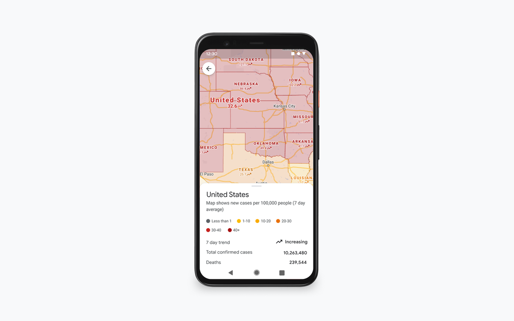
The COVID-19 pandemic is far from over, in fact, cases have spiked in the past few weeks. Google first introduced its COVID-19 layer in Maps back in September and since then it has helped it’s helped millions of people get critical information about the virus right from Google Maps.
It’s the holiday season already and Google has just updated Maps in order to give people more information about the COVID-19 situation and help them stay safe. The company announced on its official blog that two new Google Maps features will start rolling out in the coming weeks. The COVID-19 layer will show more information about the infection - all-time detected cases in a specific area, plus useful quick links to COVID related resources.
If you’re planning a trip for the holidays, these new features might come in handy. You can quickly check the situation at your destination of choice, including local COVID guidelines and testing sites.
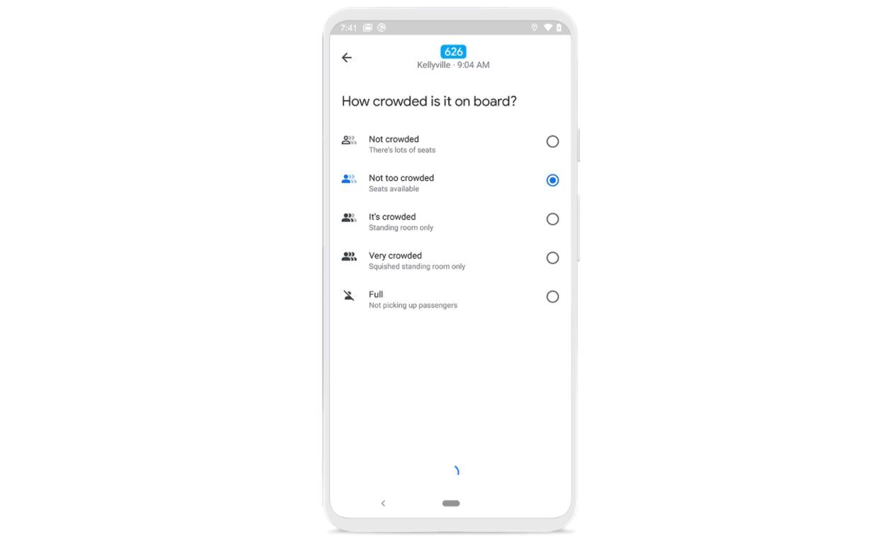
Another useful feature is the crowdedness information that Google is now showing in Maps. Both Android and iOS users will be able to see how crowded is public transport at the moment - this information is based on live feedback from other Maps users around the world.
Six-month unlimited plan is now 57% off
$90
$210
$120 off (57%)
Mint Mobile is now allowing you to get whichever plan you like for either three, six, or 12 months for just $15/mo. If you go for the six-month unlimited service, for instance, you'll now have to pay just $90 upfront instead of $210.
Mariyan, a tech enthusiast with a background in Nuclear Physics and Journalism, brings a unique perspective to PhoneArena. His childhood curiosity for gadgets evolved into a professional passion for technology, leading him to the role of Editor-in-Chief at PCWorld Bulgaria before joining PhoneArena. Mariyan's interests range from mainstream Android and iPhone debates to fringe technologies like graphene batteries and nanotechnology. Off-duty, he enjoys playing his electric guitar, practicing Japanese, and revisiting his love for video games and Haruki Murakami's works.
A discussion is a place, where people can voice their opinion, no matter if it
is positive, neutral or negative. However, when posting, one must stay true to the topic, and not just share some
random thoughts, which are not directly related to the matter.
Things that are NOT allowed:
Off-topic talk - you must stick to the subject of discussion
Offensive, hate speech - if you want to say something, say it politely
Spam/Advertisements - these posts are deleted
Multiple accounts - one person can have only one account
Impersonations and offensive nicknames - these accounts get banned
To help keep our community safe and free from spam, we apply temporary limits to newly created accounts:
New accounts created within the last 24 hours may experience restrictions on how frequently they can
post or comment.
These limits are in place as a precaution and will automatically lift.
Moderation is done by humans. We try to be as objective as possible and moderate with zero bias. If you think a
post should be moderated - please, report it.
Have a question about the rules or why you have been moderated/limited/banned? Please,
contact us.


Things that are NOT allowed:
To help keep our community safe and free from spam, we apply temporary limits to newly created accounts: