The Google Maps press event has just concluded, and while much of the presentation was expected, there were a few surprises, not the least of which is that Google will be bringing a Google Maps app to iPhone and iPad users in the “coming weeks”. It’s been widely rumored that Apple will be dumping Google as they supplier of Apple’s mapping data – and while that change will allow Apple to have more control of the data supplied over their mapping system, it also allows Google to launch its own Google Maps app for iOS.
Attendees to the even were treated to several history lessons as well as demonstrations of upcoming features. Google detailed the outreach and humanitarian benefits, including a touching story about an Amazon chief who approached Google about getting his tribe onto Google Earth to help their plight, saying it was time for his tribe to lay down their bows and arrows and pick up laptops (see photo below).
Google also touted the role that Google Earth played in the Hurricane Katrina rescue operations – their quickly updated satelite imagery of the flooded areas, combined with street data (that was otherwise underwater) and the ability to pull latitude and longitude from those services allowed for rescue responders to quickly pinpoint the locations of people calling to be rescued. Google Maps outreach engineer Rebecca Moore said that rescuers later credited them for helping them to save over 4,000 individuals.
Recommended For You
Of course in the fast-moving world of technology consumers are more often interested in what is coming next, rather than past accomplishments, and Google demonstrated several new and upcoming abilities. Google Maps offline caching appears headed for the mainstream with an easier to use UI, and the Street View team demonstrated their latest device – a packet of cameras that can be worn like an oversized back pack. This will let Google add National Parks, historical monuments, and even ski trails to the 20 petabytes of images Google has already accumulated in its attempt at comprehensive coverage.
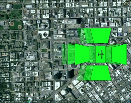
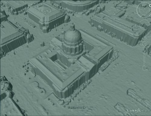
Apple is expected to demo its version of 3D maps at WWDC in a matter of days, so naturally Google pulled out its own 3D maps demonstration. Project Manager Peter Birch explained how Google’s version of 3D maps are created, explaining that airplanes fitted with the proper photogrammetry devices can fly over a city in a grid, allowing computers to extract 3D models from the data. Those models are then processed into lower resolution polygon models that are mapped with photographic data, and can then be served to computers and mobile devices anywhere.
The demonstration of the resulting map on an Android tablet was impressive – trees, cars, and other objects were rendered in 3D, with no textures lying on the ground underneath the 3D models. It’s clear the feature has a couple of stability bugs waiting to be worked out – the app crashed and had to be restarted more than once during a rapid flyover of San Francisco - but when it worked (which to be fair was most of the demo) the results were very impressive.
The first cities with this full 3D treatment will be rolling out in “a matter of weeks”, so Google appears confident that they can get it ready for prime time quickly. The biggest surprise has to be that it will be made available on both iOS and Android; clearly Google has no intention of ceding the iPhone mapping market to Apple. While the current Apple Maps app was written by Apple using Google’s back end, soon iOS users will get to choose between apps that are written from scratch by the two tech behemoths. And that sort of competition can only be a good thing for consumers.
Six-month unlimited plan is now 57% off
$90
$210
$120 off (57%)
Mint Mobile is now allowing you to get whichever plan you like for either three, six, or 12 months for just $15/mo. If you go for the six-month unlimited service, for instance, you'll now have to pay just $90 upfront instead of $210.
Scott Hartman is a former tech news writer at PhoneArena. He contributed news posts actively between 2011 and 2012.
COMMENTS (10)
COMMENTS (10)
All comments need to comply with our
Community Guidelines
PhoneArena Community Rules
A discussion is a place, where people can voice their opinion, no matter if it
is positive, neutral or negative. However, when posting, one must stay true to the topic, and not just share some
random thoughts, which are not directly related to the matter.
Things that are NOT allowed:
Off-topic talk - you must stick to the subject of discussion
Offensive, hate speech - if you want to say something, say it politely
Spam/Advertisements - these posts are deleted
Multiple accounts - one person can have only one account
Impersonations and offensive nicknames - these accounts get banned
To help keep our community safe and free from spam, we apply temporary limits to newly created accounts:
New accounts created within the last 24 hours may experience restrictions on how frequently they can
post or comment.
These limits are in place as a precaution and will automatically lift.
Moderation is done by humans. We try to be as objective as possible and moderate with zero bias. If you think a
post should be moderated - please, report it.
Have a question about the rules or why you have been moderated/limited/banned? Please,
contact us.


Things that are NOT allowed:
To help keep our community safe and free from spam, we apply temporary limits to newly created accounts: