Google Maps 5.0 overview
When Google announced its free turn-by-turn navigation service for Google Maps at the end of October 2009, the shares of Garmin, TomTom and the like took a nosedive. After all, you can't argue with free. It was not all puppies and flowers, though, since you still had to have internet connection for the map download and the voice-guided navigation, and it only worked in the US, and then UK.
A year later the turn-by-turn directions' coverage has expanded a bit with some countries in Western Europe (Austria, Belgium, Canada, Denmark, France, Italy, Germany, Netherlands, Spain and Switzerland), Canada, Australia and New Zealand. Navigation can't be compared in terms of coverage with the other free mobile service out there – Ovi Maps - which turns any GPS-equipped Nokia into a PND in almost any country that matters worldwide. Google Maps, however, was improving at a breakneck pace throughout its five year career, adding dozens of new features like Layers, Latitude, 3D Street View, Places and so on.
Google yesterday let into Android Market the latest 5.0 version of Google Maps. For the first time, the company has changed the way maps are presented, as well as the requirement to always have an Internet connection for using them. So we took Google Maps 5.0 around the block, and here's what we found:
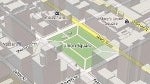
Offline(ish) navigation - Google Maps uses vector graphics now, allowing the program to dynamically draw the objects on the map when you use it. This requires up to 100 times less data than the previous method Google Maps was using, hence it can precache a vast area around your location or route. Thus, even if you lose or manually switch off your Internet connection, Google Maps can still show you the maps at various zoom levels, although we found it didn't precache entire cities, it was a few neighborhoods at best, but maybe the coverage expands with time and travel.
The software follows closely the areas you stay or travel to most, and prefetches the maps for them on your next Wi-Fi connection. There is also a setting that allows Google Maps to fetch this data over cellular Internet connection, but it has to be turned on manually.
One bonus feature of this wider area caching is that if you miss a turn now, even if you don't have Internet connection, the program will reroute you back, provided that you haven't strayed away too far. This feature wasn't yet active in our Google Maps 5.0 download, but Google said they will be rolling it gradually over the next few weeks.
Still, while nice to have, this is a far cry from a completely offline navigational solution. You still need an Internet connection to create a route, and not all services and layers of Google Maps are available in offline mode. The free Nokia Ovi Maps is way better in that respect, and even the new HTC Sense UI comes with maps of entire countries working perfectly in offline mode without costing a dime, except for voice guidance.
3D buildings, compass, two-finger tilt and rotate - 3D sounded gimmicky at first, and we had trouble figuring out where were those buildings in San Francisco at first glimpse, but they actually appear when you zoom in enough. With more than hundred cities worldwide covered, we immediately noticed added value here.
Instead of textured 3D renderings of buildings, like the ones that the popular GPS software iGO is using, Google Maps shows semi-transparent models, so you can still peep through your hotel and see which street, restaurant or museum entrance is on the other side, without tilting to bird view.
In addition, thanks to the new way the map is drawn, you can now use two fingers at once to tilt the map by sliding them up or down the screen, or rotate it around with your two digits. Couple these with the digital compass now put to good use by showing exactly which direction you are currently facing, and navigating around cities just got a whole lot easier.
We have no doubts that around the world, Google's street cars are hard at work mapping city streets, and when the process is finished, and most countries have free turn-by-turn navigation with Street View, courtesy of El Goog, then Android will become the platform of choice for many precisely because of Google Maps.
For now it is a great free mapping and navigational software with plenty of professional-grade features like live traffic, 3D views and user-generated POIs. It cannot match the best paid GPS software out there yet, at least not in all countries. Google Maps, however, achieved one very important accomplishment for us, regular users – Nokia's Ovi Maps became free too, and at the same time it brought down the prices of the best offline navigational apps to previously unthinkable levels.
A year later the turn-by-turn directions' coverage has expanded a bit with some countries in Western Europe (Austria, Belgium, Canada, Denmark, France, Italy, Germany, Netherlands, Spain and Switzerland), Canada, Australia and New Zealand. Navigation can't be compared in terms of coverage with the other free mobile service out there – Ovi Maps - which turns any GPS-equipped Nokia into a PND in almost any country that matters worldwide. Google Maps, however, was improving at a breakneck pace throughout its five year career, adding dozens of new features like Layers, Latitude, 3D Street View, Places and so on.
Google yesterday let into Android Market the latest 5.0 version of Google Maps. For the first time, the company has changed the way maps are presented, as well as the requirement to always have an Internet connection for using them. So we took Google Maps 5.0 around the block, and here's what we found:
Offline(ish) navigation - Google Maps uses vector graphics now, allowing the program to dynamically draw the objects on the map when you use it. This requires up to 100 times less data than the previous method Google Maps was using, hence it can precache a vast area around your location or route. Thus, even if you lose or manually switch off your Internet connection, Google Maps can still show you the maps at various zoom levels, although we found it didn't precache entire cities, it was a few neighborhoods at best, but maybe the coverage expands with time and travel.
Google Maps can fetch maps for offline usage now
One bonus feature of this wider area caching is that if you miss a turn now, even if you don't have Internet connection, the program will reroute you back, provided that you haven't strayed away too far. This feature wasn't yet active in our Google Maps 5.0 download, but Google said they will be rolling it gradually over the next few weeks.
Still, while nice to have, this is a far cry from a completely offline navigational solution. You still need an Internet connection to create a route, and not all services and layers of Google Maps are available in offline mode. The free Nokia Ovi Maps is way better in that respect, and even the new HTC Sense UI comes with maps of entire countries working perfectly in offline mode without costing a dime, except for voice guidance.
3D buildings, compass, two-finger tilt and rotate - 3D sounded gimmicky at first, and we had trouble figuring out where were those buildings in San Francisco at first glimpse, but they actually appear when you zoom in enough. With more than hundred cities worldwide covered, we immediately noticed added value here.
Instead of textured 3D renderings of buildings, like the ones that the popular GPS software iGO is using, Google Maps shows semi-transparent models, so you can still peep through your hotel and see which street, restaurant or museum entrance is on the other side, without tilting to bird view.
3D buildings at different levels of tilt and zoom
In addition, thanks to the new way the map is drawn, you can now use two fingers at once to tilt the map by sliding them up or down the screen, or rotate it around with your two digits. Couple these with the digital compass now put to good use by showing exactly which direction you are currently facing, and navigating around cities just got a whole lot easier.
We have no doubts that around the world, Google's street cars are hard at work mapping city streets, and when the process is finished, and most countries have free turn-by-turn navigation with Street View, courtesy of El Goog, then Android will become the platform of choice for many precisely because of Google Maps.
For now it is a great free mapping and navigational software with plenty of professional-grade features like live traffic, 3D views and user-generated POIs. It cannot match the best paid GPS software out there yet, at least not in all countries. Google Maps, however, achieved one very important accomplishment for us, regular users – Nokia's Ovi Maps became free too, and at the same time it brought down the prices of the best offline navigational apps to previously unthinkable levels.

Popular stories


Latest News


Things that are NOT allowed:
To help keep our community safe and free from spam, we apply temporary limits to newly created accounts: