Update to Google Maps in selected markets adds interesting AI feature
Google adds new features to Google Maps in Europe, including one that finds the quickest mode to your destination.

Google Maps has pushed out an update that is meant for users of the app in Europe. When you type in your destination, Google Maps typically searches for multiple routes for the navigation option you've selected (car, walking, public transportation, etc.). However, with the addition of AI, Google Maps will check the estimated time of arrival (ETA) of other modes to your destination. If you can reach your destination faster using public transportation or by walking, you'll see those directions on the display instead of directions for driving.
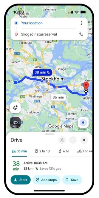
If a different mode of transportation is faster than driving, Google Maps will show you directions using that mode. | Image credit-PhoneArena
For example, let's say that you have Google Maps set up for driving directions and the app determines that you'll reach your destination faster by taking public transportation. Google Maps will then show you those suggested routes. Not only will you arrive earlier, by taking the bus you are reducing pollution, conserving gas, and doing your part to protect and preserve natural resources. This new feature is available in 60 European cities including Stockholm, Warsaw. and Copenhagen.
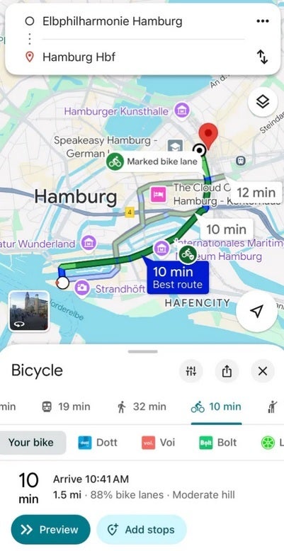
In Europe, cycling is huge and Google Maps is adding cycling navigation to 17 new cities with nine of them located in Europe. The app now shows 125,000 kilometers (equal to 77,671 miles) of bike lanes in cities such as Hamburg, Madrid, Barcelona, Milan, Rome, Zurich, Budapest, Vienna, and Brussels. Google is using data obtained from local governments and public authorities.
Since Google Maps is looking to get travelers to be more judicious in their consumption of natural resources, it now offers fuel-efficient routes worldwide. Previously, this feature was available only in certain regions. When you type a destination on the app, the fuel-efficient route is listed as an alternative. Each route also shows its ETA so that you'll know how much later you'll arrive at your destination by taking the more fuel-efficient option.
Fuel-efficient directions show you how much gas you'll save when using this route. | Image credit-PhoneArena
Google Maps is also adding support for low-emission zones which will impact drivers in Italy, Sweden, Austria, and other locations. Google Maps will send alerts that will "check if your vehicle is allowed in these zones." You can ask the app to create an alternate route that bypasses the low-emission zones. Google Maps will support over 1,000 low-emission zones.
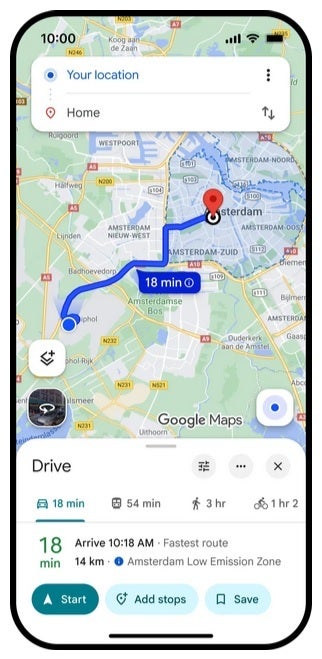
Google Maps now supports low-emission zones and will let you know if your car can drive into this zone. | Image credit-PhoneArena
Project Green Light uses AI and Google Maps driving trends to help recommend to cities how they can improve their existing traffic light cycles. Project Green Light is available in 20 cities across four continents.

Popular stories


![Verizon denies SpaceX is buying it [UPDATED]](https://m-cdn.phonearena.com/images/article/182254-wide-two_350/Verizon-denies-SpaceX-is-buying-it-UPDATED.webp)

Latest News


Things that are NOT allowed:
To help keep our community safe and free from spam, we apply temporary limits to newly created accounts: