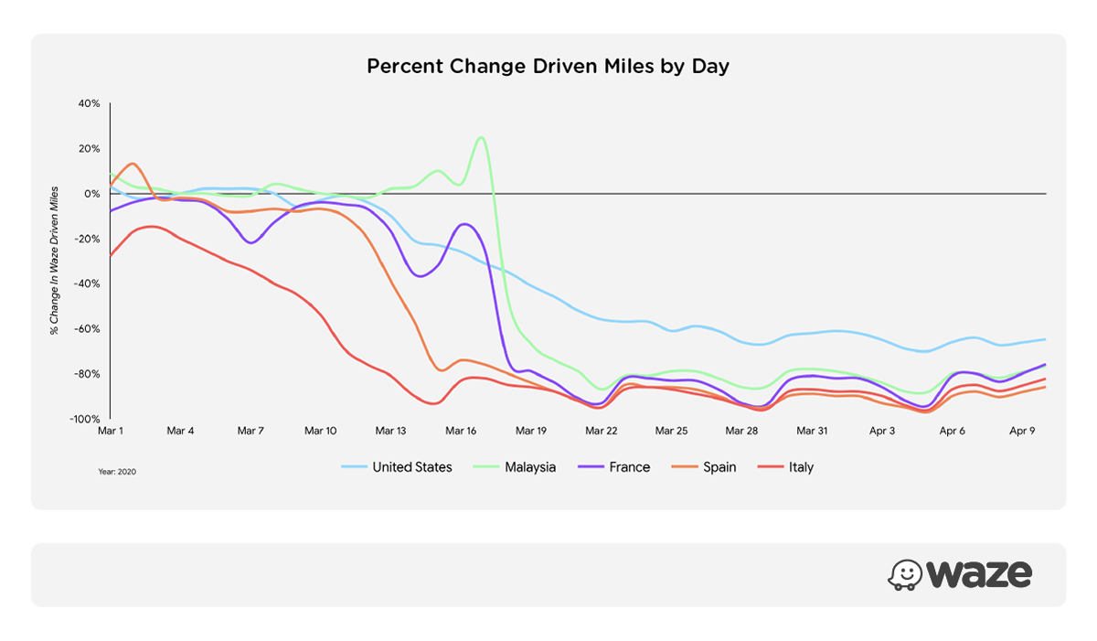
People don't go anywhere these days, and data from the Google-owned app Waze confirms it. There's not much driving happening when a lockdown is in place, but when people do get behind the wheel, they're most likely taking care of important business. And when you have to get from point A to B as fast as possible, any help is appreciated. Waze knows this and wants to help drivers reach their destination fast and trouble-free, Engadget reports.
The team behind the navigation app turned to public agencies, partners, and communities to offer COVID-19-related information. More than 30,000 map editors from Waze's community around the world provided data about road closures, red zones, checkpoints, and traffic congestion. The company has created a COVID-19 landing page that allows people and organizations to submit critical information on the locations of medical testing centers, emergency food distribution centers, and road closures.
Waze is also partnering with WhyHunger and No Kid Hungry to add more than 30,000 emergency food distribution locations to the US map. There's also a new feature in the app that shows local businesses that offer drive-thru and curbside pickup options. You should already be able to see COVID-19 related info on Waze, as the company is rolling out the updates as we type.
Six-month unlimited plan is now 57% off
$90
$210
$120 off (57%)
Mint Mobile is now allowing you to get whichever plan you like for either three, six, or 12 months for just $15/mo. If you go for the six-month unlimited service, for instance, you'll now have to pay just $90 upfront instead of $210.
Mariyan, a tech enthusiast with a background in Nuclear Physics and Journalism, brings a unique perspective to PhoneArena. His childhood curiosity for gadgets evolved into a professional passion for technology, leading him to the role of Editor-in-Chief at PCWorld Bulgaria before joining PhoneArena. Mariyan's interests range from mainstream Android and iPhone debates to fringe technologies like graphene batteries and nanotechnology. Off-duty, he enjoys playing his electric guitar, practicing Japanese, and revisiting his love for video games and Haruki Murakami's works.
A discussion is a place, where people can voice their opinion, no matter if it
is positive, neutral or negative. However, when posting, one must stay true to the topic, and not just share some
random thoughts, which are not directly related to the matter.
Things that are NOT allowed:
Off-topic talk - you must stick to the subject of discussion
Offensive, hate speech - if you want to say something, say it politely
Spam/Advertisements - these posts are deleted
Multiple accounts - one person can have only one account
Impersonations and offensive nicknames - these accounts get banned
To help keep our community safe and free from spam, we apply temporary limits to newly created accounts:
New accounts created within the last 24 hours may experience restrictions on how frequently they can
post or comment.
These limits are in place as a precaution and will automatically lift.
Moderation is done by humans. We try to be as objective as possible and moderate with zero bias. If you think a
post should be moderated - please, report it.
Have a question about the rules or why you have been moderated/limited/banned? Please,
contact us.


![Verizon denies SpaceX is buying it [UPDATED]](https://m-cdn.phonearena.com/images/article/182254-wide-two_350/Verizon-denies-SpaceX-is-buying-it-UPDATED.webp)


Things that are NOT allowed:
To help keep our community safe and free from spam, we apply temporary limits to newly created accounts: