
New helpful features are added to Google Maps

Google continues to work on Google Maps as the app matures from one that gets you safely and quickly from point "A" to point "B" to one that not only gets you to point "B" but also shows you where to go, stay, eat and more once you do arrive at point "B." Today, Google announced some new features for Maps that are designed to help users deal with some of the pains of travel whether it is the daily commute to the office, a vacation, or just a jaunt to the local supermarket to stock up.
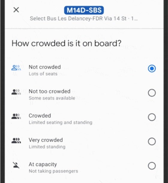
New features for Google Maps include one that reports on how crowded your train, subway, or bus is.
The new features for Google Maps include one that will come in handy for commuters and others. If you happen to rely on public transit for the majority of your trips, you can now get the lay of the land and discover how crowded your subway car, bus, or train will be. This is important if you hate getting squeezed inside a subway car with sweaty, irritable commuters.
Google Maps will soon be able to inform you how crowded your bus, train, or subway car is
If Google Maps informs you that you should expect a cramped ride, you can always wait for the next subway car, bus or train so that you can enjoy some space and perhaps more importantly, some peace and quiet on your journey. The information is computed using machine learning AI and will soon be expanded to cover more than 10,000 transit agencies in 100 countries around the world.
In New York and Sydney, Google is testing the release of this information for the individual car levels on trains. This will allow Google Maps users to choose where to stand on the platform in order to find the least crowded part of the train.
With new variants of COVID like Delta and the deadly Lambda versions keeping the pandemic alive, Google knows that it is still important for people to know the latest news about COVID-19. The COVID layer on Google Maps will provide information about what is happening in your area about COVID including restrictions that you need to know about and local resources that you might find helpful.
Google suggests that before you leave for your destination, go to Google Maps, search for your destination and scroll down to the Business Profile to see how busy the place is right now. This way you can adjust your plans if your destination is mobbed. Some businesses allow you to schedule an appointment through Google Maps. All you need to do is search for the business, check availability, and reserve your time. You can make changes and manage your appointments via the app's Saved tab.
Make contactless payments for street parking or public transit straight from Google Maps
Google Maps will soon allow you to look back in order to plan ahead. All Android users can use the Trips tab to revisit past trips. Google notes that you can export this information and share your past travels with others.
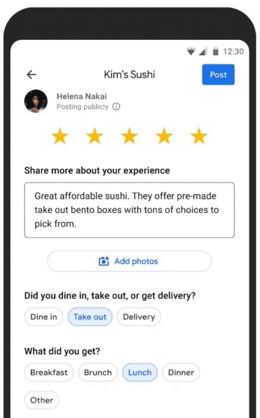
Leave reviews for the places you visited
The Business Profile will also show a location's operating hours, current COVID-19 safety precautions, trending dishes, and reviews. Speaking of dishes, tapping on prompts inside Google Maps will allow you to share information for any restaurant in the U.S. including the eatery's average price range or whether you ate in or took the meal home to consume.
Lastly, Google Maps will allow users to pay for things like street parking or public transit directly from the app. For the former, type in the meter number and then hit pay and refill to make the contactless payment. When you arrive at any public transit, your phone will show an option to make a payment which you can tap to initiate.

Popular stories


Latest News


Things that are NOT allowed:
To help keep our community safe and free from spam, we apply temporary limits to newly created accounts: