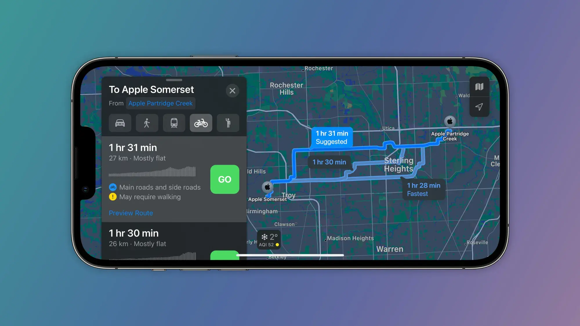
Apple Maps is now getting even more useful with a new update, reports 9to5Mac. Back with iOS 14, Apple Maps introduced cycling directions in order to help cyclists find the best route with bike lanes. Now, Apple is expanding this feature and adding cycling directions for people located in Chicago, Detroit, and other Midwestern US cities.
Apple Maps expands cycling directions to Chicago, Detroit, and other cities
This update has been quietly rolled out to Apple Maps users a few days ago. The Maps app now shows cycling directions in the following cities: Chicago, Detroit, Indianapolis, Cleveland, Columbus, Cincinnati, and Charleston.
The cool thing about this update is that it doesn't only show the best routes you can travel with your bicycle, but also details elevation info, as well as how busy the road is. On top of that, you get options for avoiding routes with hills so you don't break a sweat trying to conquer them with your bike.
Before this update, Apple Maps had cycling directions for California, New York, Toronto, Vancouver, London, and mainland China.
On top of the useful features such as finding the best bike lane or bike-friendly road, and elevation, Maps can also speak cycling-specific directions for turns as you go.
Recommended For You
Earlier this month, the feature was expanded to parts of the US Northeast, and according to Justin O’Beirne, who highlighted the update, the areas next on the line for the cycling directions expansion are Texas and the Gulf Coast, so hopefully you won't have to wait too much if you live in those regions.
Overall, Apple Maps now has cycling directions for around 26% of the territory of the United States, and almost 52% of the US population is covered.
Get Visible as low as $20/mo for 1 year. Limited time offer with code: FRESHSTART
$20
/mo
$25
$5 off (20%)
Offer Ends 6.1.2026 at 11.59pm ET. New members get $5/mo off the $25/mg Visible plan, $35/mo Visible+ plan, or $45/mo Visible+ Pro plan for the first 12 months. Promo code FRESHSTART required at checkout.
Iskra Petrova is a news writer at PhoneArena, where she covers mobile tech news and maintains the site’s device hubs with the latest leaked specs, rumors, and official details for upcoming phones. She joined PhoneArena in 2020 after three years in technical support for Microsoft Exchange, giving her practical experience with software infrastructure and troubleshooting. Iskra holds a Master’s Degree in Literature, which helps her translate complex tech details into clear, reader-friendly coverage. She is a daily Apple ecosystem user, while also closely following Sony Xperia’s camera-focused phones and Samsung’s Galaxy Z Flip series.
A discussion is a place, where people can voice their opinion, no matter if it
is positive, neutral or negative. However, when posting, one must stay true to the topic, and not just share some
random thoughts, which are not directly related to the matter.
Things that are NOT allowed:
Off-topic talk - you must stick to the subject of discussion
Offensive, hate speech - if you want to say something, say it politely
Spam/Advertisements - these posts are deleted
Multiple accounts - one person can have only one account
Impersonations and offensive nicknames - these accounts get banned
To help keep our community safe and free from spam, we apply temporary limits to newly created accounts:
New accounts created within the last 24 hours may experience restrictions on how frequently they can
post or comment.
These limits are in place as a precaution and will automatically lift.
Moderation is done by humans. We try to be as objective as possible and moderate with zero bias. If you think a
post should be moderated - please, report it.
Have a question about the rules or why you have been moderated/limited/banned? Please,
contact us.


Things that are NOT allowed:
To help keep our community safe and free from spam, we apply temporary limits to newly created accounts: