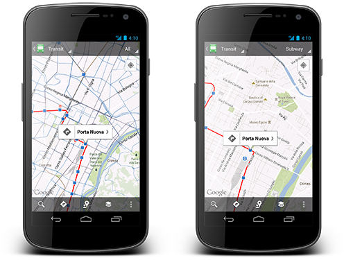
Google Maps is getting even more useful for those of you who rely on public transportation on your daily commute. Google has been working hard to build in reliable information for public transit systems across the world, and today Google is really showing off the work that has been done with a new update. Google starts off by mentioning that Maps now has information for over 1 million public transit stations and stops.
The update of Google Maps for Android will bring the app to version 6.1 and focuses on those public transport stops. The big feature of the update is a refreshed UI for the public transportation stop pages. These pages have been an easy way to get info on what lines run at a certain stop and when trains or buses are expected, but the new update makes it much easier to navigate the information, and find nearby stations.
Additionally, the update adds more options to see your personal data, including additions to the My Places tab, and more granular control in seeing the places you've visited in your location history. It also brings in a feature that have been in Google Maps proper for a while which highlights a city, neighborhood, region, or zip code when you search for it.
The update wasn't live at the time of this writing, but it should hit the Google Play Store today.
Mint Mobile is now allowing you to get whichever plan you like for either three, six, or 12 months for just $15/mo. If you go for the six-month unlimited service, for instance, you'll now have to pay just $90 upfront instead of $210.
Michael Heller is known for his clear and informative articles on mobile technology. He explores important topics such as the rollouts of 5G networks and the advancements in mobile payments, offering readers insights into the evolving tech landscape.
COMMENTS (11)
COMMENTS (11)
All comments need to comply with our
Community Guidelines
PhoneArena Community Rules
A discussion is a place, where people can voice their opinion, no matter if it
is positive, neutral or negative. However, when posting, one must stay true to the topic, and not just share some
random thoughts, which are not directly related to the matter.
Things that are NOT allowed:
Off-topic talk - you must stick to the subject of discussion
Offensive, hate speech - if you want to say something, say it politely
Spam/Advertisements - these posts are deleted
Multiple accounts - one person can have only one account
Impersonations and offensive nicknames - these accounts get banned
To help keep our community safe and free from spam, we apply temporary limits to newly created accounts:
New accounts created within the last 24 hours may experience restrictions on how frequently they can
post or comment.
These limits are in place as a precaution and will automatically lift.
Moderation is done by humans. We try to be as objective as possible and moderate with zero bias. If you think a
post should be moderated - please, report it.
Have a question about the rules or why you have been moderated/limited/banned? Please,
contact us.


![Verizon denies SpaceX is buying it [UPDATED]](https://m-cdn.phonearena.com/images/article/182254-wide-two_350/Verizon-denies-SpaceX-is-buying-it-UPDATED.webp)


![T-Mobile continues to experience major network issues across the nation [UPDATED]](https://m-cdn.phonearena.com/images/article/182238-wide-two_350/T-Mobile-continues-to-experience-major-network-issues-across-the-nation-UPDATED.webp)


Things that are NOT allowed:
To help keep our community safe and free from spam, we apply temporary limits to newly created accounts: