It's no secret that Apple has been working on building an alternative maps application for iOS. Once Google really started to make some moves in the mobile space with Android, Apple ramped up acquisitions that all seem to be pointing towards a proprietary maps application that will replace Google Maps on iOS devices. However, there is a lot more to a successful maps application than just navigation, and we're wondering how long it will take Apple to get its own maps up to speed, and by then, if it really makes any difference for the platform.
Apple's acquisitions
The story of Apple's Maps project (for simplicity we'll just call it Apple Maps) began just over 2 years ago in July of 2009 when Apple quietly purchased Placebase, which was the company that had created the PushPin API behind the Openplaces project. Both Placebase and Openplaces have essentially disappeared from the web since that acquisition. As of this writing, the Openplaces site couldn't be found, and the main page for Placebase just forwards to an overview of the PushPin API. The founder and CEO of Placebase, Jaron Waldman, has had his position on LinkedIn listed as being part of the Geo Team at Apple since that acquisition.
Recommended For You
The PushPin API and other products which Apple bought in that acquisition will likely form the base of Apple Maps, because it includes not only the actual maps of the world, but a surprising array of features which can be added onto the maps. PushPin includes not only the basic features of finding places and adding custom place pins, but also includes options for adding custom widgets and layers to maps. The layers are where a lot of the power of the product had been derived. Much like how we've seen flu maps, and or custom data sets added to Google Maps, PushPin offers a powerful set of tools to create custom data maps. It actually was quite an impressive program, and we wouldn't be surprised if most of the work that Apple has put into it is in simplifying the features and making it more user friendly.
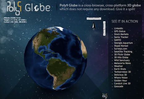
The next piece of the puzzle was Poly9. This was another quiet purchase by Apple, this one made in July of 2010. Poly9 was a Quebec-based startup which had used a number of different open tools including the PushPin API to create a Flash-based Google Earth clone called "Poly9 Globe". Of course, that product has also disappeared from the net since the acquisition. The prevailing theory is that Poly9 was acquired more for the programming team than for the actual product it had created.
The latest piece was C3 Technologies, which Apple apparently purchased last year, but the details of the acquisition were kept so tightly secret that it wasn't until this past week that Apple was uncovered to be the owner of the company. C3 has created some incredibly impressive tech, which allows 3D imaging to be built from traditional 2D maps and images. This is very similar to what Google has been doing with its own Maps product with the new MapsGL features. The video demo of C3's technology is pretty impressive too:
Get Visible as low as $20/mo for 1 year. Limited time offer with code: FRESHSTART
$20
/mo
$25
$5 off (20%)
Offer Ends 6.1.2026 at 11.59pm ET. New members get $5/mo off the $25/mg Visible plan, $35/mo Visible+ plan, or $45/mo Visible+ Pro plan for the first 12 months. Promo code FRESHSTART required at checkout.
Michael Heller is known for his clear and informative articles on mobile technology. He explores important topics such as the rollouts of 5G networks and the advancements in mobile payments, offering readers insights into the evolving tech landscape.
Recommended For You
COMMENTS (116)
COMMENTS (116)
All comments need to comply with our
Community Guidelines
PhoneArena Community Rules
A discussion is a place, where people can voice their opinion, no matter if it
is positive, neutral or negative. However, when posting, one must stay true to the topic, and not just share some
random thoughts, which are not directly related to the matter.
Things that are NOT allowed:
Off-topic talk - you must stick to the subject of discussion
Offensive, hate speech - if you want to say something, say it politely
Spam/Advertisements - these posts are deleted
Multiple accounts - one person can have only one account
Impersonations and offensive nicknames - these accounts get banned
To help keep our community safe and free from spam, we apply temporary limits to newly created accounts:
New accounts created within the last 24 hours may experience restrictions on how frequently they can
post or comment.
These limits are in place as a precaution and will automatically lift.
Moderation is done by humans. We try to be as objective as possible and moderate with zero bias. If you think a
post should be moderated - please, report it.
Have a question about the rules or why you have been moderated/limited/banned? Please,
contact us.


Things that are NOT allowed:
To help keep our community safe and free from spam, we apply temporary limits to newly created accounts: