
Apple Maps will also get some much needed love - public transport directions and other goodies coming with iOS 9
That may be so, but the navigational service is still lacking a pretty important feature, which, thankfully, will be coming with the next iOS update. We are talking about the new Transit option, of course!
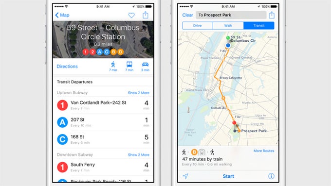
The new feature will allow Apple Maps to show detailed routes and station information to help users navigate public transportation. Not only that, but it will attempt to bring super-accurate distance information so that it can calculate travel time as accurately as possible. For example, train stations will not be treated as a point on the map – their actual size will be taken into account, and the distance you need to travel to actually reach your train when you are on-site will be included in the calculations, making sure that you don't miss to board.
Maps will also have a deeper integration with Siri, allowing you to ask the assistant to instantly start up a navigation via Transit. Additionally, the app will now allow you to find nearby restaurants, shops, and other businesses, and you will be able to spot the ones that support Apple Pay thanks to a specially placed indicative icon.
Cities to get the Transit service on launch

Popular stories


Latest News


Things that are NOT allowed:
To help keep our community safe and free from spam, we apply temporary limits to newly created accounts: