GPS platform and other factors lead a driver to his death
Ever since turn-by-turn directions became available for free with Android 2.0 and the launch of the Motorola DROID in 2009, many drivers use Google Maps, Apple Maps, or third-party apps (some of which do charge) to safely and quickly get from point "A" to point "B." The problem is that we follow these directions without thinking about how accurate they might be.
GPS platform leads 47-year-old man to drive over a bridge that had been washed out for nine years
After all, when Apple first launched Apple Maps in 2012, it was a mess. Some countries, if they were labeled at all, were incorrectly identified. And some directions in Australia accidentally took drivers into the Outback. Those following the directions ended up in an area consisting of roughly 3,000 square miles with poisonous snakes, temperatures as high as 115 degrees Fahrenheit, and limited cellphone coverage. Apple CEO Tim Cook apologized and Apple has since built its own much improved mapping platform from the ground up.
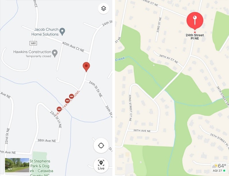
Google Maps (L), Apple Maps (R) of the area where the accident occurred
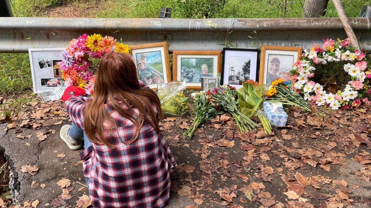
Now we don't know exactly which GPS platform 47-year-old Philip Paxson was using at the end of last month when he was driving in North Carolina at night from a birthday party for his older daughter. According to Fox News, the directions he was blindly following took him to a bridge that had been out of commission since July 2013 when floods wiped it out. Without any warning signs or barricades (which had allegedly been washed out by a previous storm), Paxson drove his 2020 Jeep Gladiator on the bridge which took him into the river where he died.
On Facebook, Paxson’s mother-in-law, Linda McPhee Koenig, explained what happened. "It was a dark and rainy night and he was following his GPS which led him down a concrete road to a bridge that dropped off into a river. The bridge had been destroyed [nine] years ago and never repaired. It lacked any barriers or warning signs to prevent the death of a 47 year old [sic] father of two daughters. He will be greatly missed by his family and friends. It was a totally preventable accident. We are grieving his death."
The family set up a Go Fund Me page that says, "We are all in shock and disbelief. This was a preventable accident, the bridge he went over at night had a gaping hole and there were no barricades. It had been this way for many years. No one would take responsibility to repair it and now he has to pay the price. Please pray for our family during this most difficult time."
What you can do to avoid a similar situation
Even though the report notes that the police responded to reports of an overturned car in a creek off of a private road, the point is that the GPS platform he was using took Paxson to that location. As another one of Paxson's relatives said, "He didn’t fall off a bridge. He didn’t drive off a bridge. He drove to his death through that 20 [foot] ravine."
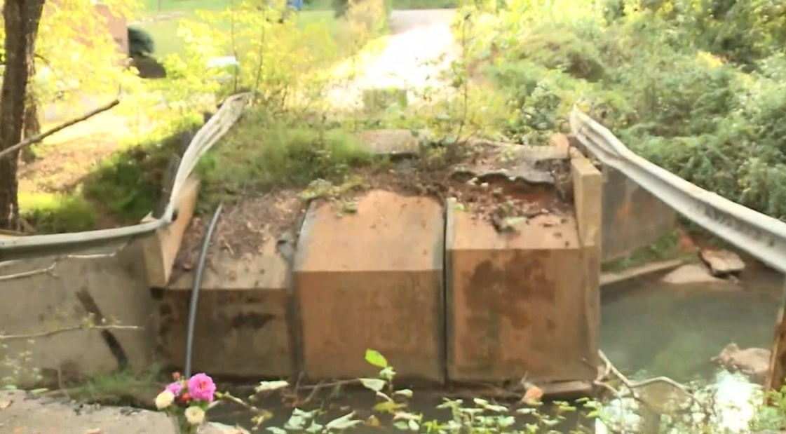
Image of the bridge taken from WCNC News
There is a lesson to be learned here, but it is hard to adhere to. If you plan on driving in an area that you might not be familiar with, especially at night, you might want to call the police near your destination and ask if there are any bridges out along the route. While this might have been an extremely rare situation, you don't want to suddenly realize that you've driven on a bridge that is no longer active.
And there are plenty of institutions that deserve to be blamed here. Even if it was on a private road, there should have been signs or barricades to prevent any vehicles from getting near the bridge. And the report doesn't mention which GPS platform was involved in this accident, but regardless of who was responsible for the faulty navigation, you can't escape the fact that it was nighttime, visibility was impacted by the rain, and the driver was led to the bridge by the GPS platform he used.
WCNC quoted Kayla Bubar, Paxson's sister-in-law, as saying that "He took a left and that left went to that bridge to nowhere, which is what they called it since 2013 when that bridge washed away and no one took responsibility to get that bridge fixed."
As we've stated, the road shows up on GPS. Bubar explained why her now deceased brother-in-law might have had punched in the road with the bridge. "He could have easily put it in the GPS and gone this way because all of the neighbors say the quickest way out of here is that way. And most people choose the quickest way. My sister’s friend drove up to that edge multiple times but thankfully it was daytime."
This is something that might have easily happened to any one of us.
Popular stories


Latest News


Things that are NOT allowed:
To help keep our community safe and free from spam, we apply temporary limits to newly created accounts: