Google Maps is giving out potentially fatal directions to mountain climbers
When Apple launched its own mapping and navigation app in iOS 6, the goal was to replace Google Maps on the iPhone. But Apple Maps was such a fiasco that just weeks after the launch, CEO Tim Cook apologized for Apple Maps' shortcomings and suggested that iOS users turn to alternatives like Google Maps, Waze, and other navigation apps until the issues were fixed.
Following Google Maps' directions hiking to the top of certain mountains could end your life
One particular mistake put Apple Maps users in real peril and led Inspector Simon Clemmence of the Victoria Police in Australia to call the app life-threatening. It turned out that the directions that the app provided to at least six people driving their vehicles to Mildura took them through the Outback with temperatures as high as 115 degrees. The area is lousy with poisonous snakes and cell reception is spotty.
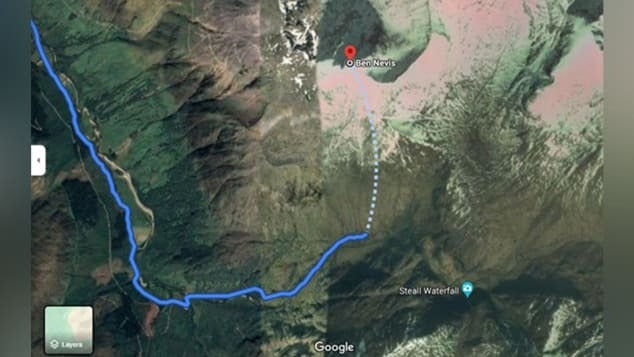
This image shows a dangerous route suggested by Google Maps to climb up Scotland's tallest mountain
The problem was that Apple Maps had Mildura 43 miles away from its actual location. Australian cops put out a warning telling iPhone users that drivers who used the app to get to Mildura ended up driving for over 24 hours without food, water, or cell service. One person had to walk over 24 hours before finding cellular connectivity for his handset. Apple Maps has been greatly improved since and now it is Google Maps' turn to disseminate potentially deadly directions.
At the end of last week, the John Muir Trust and Mountaineering Scotland (via Gizmodo), the organizations that watch over mountain climbing, hill walking, snow sports, and similar activities in Scotland, released a warning. The organization expressed concern that climbers and hikers were using navigation apps to get directions to Scotland's highest mountain named Ben Nevis.
It seems that Google Maps is giving directions to hikers that could be lethal. At least that is the opinion of Heather Morning, Mountaineering Scotland’s mountain safety adviser. Morning says that "For those new to hill walking, it would seem perfectly logical to check out Google Maps for information on how to get to your chosen mountain...even the most experienced mountaineer would have difficulty following this route (from Google Maps)."
Morning adds that "the line goes through very steep, rocky, and pathless terrain where even in good visibility it would be challenging to find a safe line. Add in low cloud and rain and the suggested Google line is potentially fatal." Both organizations wish to speak to Google about removing any life-threatening routes. However, Google has reportedly yet to respond to appeals from John Muir.
A Google spokesperson did comment about the possibly life-threatening directions and said, "We built Google Maps with safety and reliability in mind, and are working quickly to investigate the routing issue on Ben Nevis and surrounding areas."
Google told CNN that it examining the issue and said, "To help both novice and experienced hikers more easily find trails that suit their level of expertise, we’re now updating our driving routes to take people directly to the visitor center, where they’ll be able to speak with staff about the best trail to take." But the directions to Ben Nevis are not the only directions from Google Maps that could end up killing someone who follows the app's directions (more on that below).
Mountaineering Scotland says that too many climbers put their trust in navigation apps
Mountaineering Scotland's Morning states "Modern navigation technology brings some amazing advantages for hill walkers, but this example is clearly not one of them. Walkers and climbers with even a little experience will know to read information from a map, whether digital or paper, and if they are looking for downloadable routes know to use reputable sources and check several sources to ensure the information they are accessing is the right route for their level of experience and ability."
She goes on to say that "...especially on Ben Nevis, many people are not aware of where to get reliable information and may quite naturally assume that Google Maps, which got them from their home to the foot of the mountain, can carry on and do the job right to the top. This is not the case."
She goes on to say that "...especially on Ben Nevis, many people are not aware of where to get reliable information and may quite naturally assume that Google Maps, which got them from their home to the foot of the mountain, can carry on and do the job right to the top. This is not the case."
A couple of paragraphs ago we hinted that there is another possible fatal set of directions offered by Google Maps. According to Mountaineering Scotland, a route shared by Google Maps to Scotland's An Teallach mountain "would take people over a cliff." Ouch!

Popular stories


Latest News


Things that are NOT allowed: